↓
 

Midland Land Surveying

Local Land Surveyors in Midland, TX

Midland Land Surveying
  • Home
  • ALTA Survey
  • Boundary Surveying
  • Construction Survey
  • Drone LiDAR Mapping
  • Elevation Certificate
  • Land Surveying
  • Topographic Survey
  • Blog
  • Contact Us
Home 1 2 3 … 10 11 >>

Post navigation

← Older posts

Welcome to Midland Land Surveying

Midland Land Surveying Posted on August 18, 2017 by MidlandSurveyorMarch 24, 2020

Your Final Stop for ALL of Your Survey Needs!                                         Contact us today for a free quote!

This site is intended to provide you with information on Land Surveying in the Midland, TX and Midland County area of Texas. If you’re looking for a Midland Land Surveyor, you’ve come to the right place. If you’d rather talk to someone about your land surveying needs, please call our local number at (432) 315-2010 today. For more information, please continue to read.

land surveyingLand Surveyors are professionals who txke precise measurements to determine the size and boundaries of a piece of real estate.  While this is a simplistic definition, boundary surveying is one of the most common types of surveying related to home and land owners. If you fall into the following categories, please click on the appropriate link for more information on that subject:
Midland Land Surveying services:

    1. I need to know where my property corners or property lines are. (Boundary Survey)
    2. I have a loan closing or re-finance coming up on my home in a subdivision. (Lot Survey)
    3. I need a txp of my property with contour lines to show elevation differences for my architect or engineer. (Topo Survey)
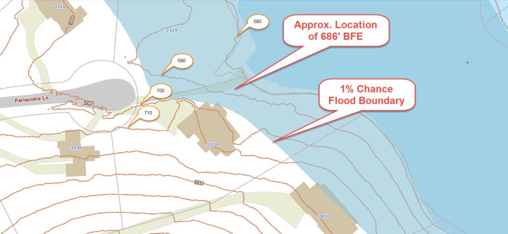
    4. I’ve just been told I’m in a flood zone or I’ve been told I need an elevation certificate in order to obtain flood insurance or prove I don’t need it. (Flood Survey)
    5. I’m purchasing a lot/house in a recorded subdivision. (Lot Survey – See Boundary Survey if you’re not in a subdivision.)
    6. I’m purchasing a larger tract of land, acreage, that hasn’t been subdivided in the past. (Boundary Survey)

Contact Midland Land Surveying services TODAY at (432) 315-2010.

Posted in boundary surveying, elevation certificate, land surveying, land surveyor | Tagged boundary survey, land surveyor, land surveyor midland tx, Midland Land Surveying

Average Cost for a Land Survey Before Combining or Splitting City Lots

Midland Land Surveying Posted on September 9, 2026 by MidlandSurveyorSeptember 7, 2026
Average cost for a land survey for a residential city lot in Midland Texas before combining or splitting property.

Two neighbors want to join their lots into one. A homeowner wants to split a big lot into two smaller ones. Either way, everyone asks the same question first. What’s the average cost for a land survey going to be? There’s no single price that fits every lot. The shape of the land, its history, and what’s already built on it all change the price.

Why the Shape of a City Lot Can Change the Cost of a Land Survey

Not all city lots are built the same way, and that’s a big reason prices can vary so much from job to job.

A narrow lot squeezed between two houses takes more careful work than a wide, open lot with room to move around. Corner lots border two streets instead of one, which means more boundary lines to measure and more records to pull for each street. Odd-shaped lots, the kind with slanted edges or curves instead of clean rectangles, take longer to measure accurately and longer to calculate afterward.

Older city blocks add another layer of work. Many blocks were laid out decades ago, and the original lot lines don’t always match today’s tax records. Surveyors often spend extra time matching old maps against what’s actually on the ground now. When a project involves several lots sitting next to each other, all of this adds up fast. Each additional lot means another boundary to check and another set of records to track down.

None of this means a small or odd-shaped lot is impossible to survey. It just takes longer, and that extra time shows up in the final price.

How Old Markers and Lot Corners Affect the Price

Every land survey relies on small markers buried or set in the ground. These markers, called monuments, might be metal pins, pipes, or blocks of concrete that show exactly where a lot of corners sit. How easy these are to find can change the entire scope of a job.

When a marker is clearly visible and hasn’t shifted, a surveyor can confirm the corner quickly and move on. That keeps the fieldwork efficient. But older city lots don’t always offer that convenience. Years of construction, landscaping, and repaving can bury a marker, damage it, or wipe it out completely. When that happens, the surveyor has to dig deeper, and sometimes that means literal digging. They compare recorded plats, check evidence from neighboring lots, and take fresh measurements to figure out where the corner originally stood.

This kind of work takes real time. A lot with clear, undisturbed markers will almost always cost less to survey than one where the evidence has been buried or lost.

Why Joining Several Lots Usually Means More Paperwork to Check

Splitting or combining lots almost never involves just one deed. Each parcel usually carries its own paper trail, and a surveyor has to untangle all of it before the job can be done accurately.

Separate deeds might describe the very same boundary in slightly different wording, even for lots that sit right next to each other. Older plats sometimes use measurements or reference points that don’t line up with how the city describes the land today. Tax records can lag behind too, occasionally missing boundary changes that were made years earlier.

When several lots are part of one project, the surveyor has to pull every record and compare them side by side. That step takes real time, especially when the old descriptions don’t match cleanly. More lots generally means more paperwork, and more paperwork means more hours spent researching before anyone even sets foot on the property.

Things Already Built on the Land Can Add to Survey Time

City lots are rarely empty. Garages, fences, driveways, retaining walls, and buried utility lines all sit on the surface, and every one of them can slow a survey crew down.

A fence built close to a boundary line has to be measured with extra care, since its real position is often a little different from where people assume the property line falls. Walls and driveways near a corner make things trickier too, since the crew has less open space to set up and move their equipment. Buried pipes and other utility features sometimes need to be marked and worked around while the crew is on site.

Crowded lots are simply harder to measure overall. A crew working on a tight urban lot has less room between one corner and the next, and every obstacle adds a few more minutes to the job. All of this extra time in the field eventually shows up on the final bill.

What to Give a Surveyor When Asking for a Price Quote

A vague request usually gets a vague answer back. Giving a surveyor clear details upfront leads to a faster, more accurate quote, and it saves both sides from a long round of back-and-forth questions.

Start with the property address and how many lots are actually part of the project. If you have old deeds or plats sitting in a drawer somewhere, share them. These documents give the surveyor a real head start before the crew ever arrives. Be clear about your goal as well. Are you joining lots into one property? Splitting one lot into two separate parcels? Shifting a shared boundary line slightly? State it plainly.

Mention anything unusual you already know about the site. Maybe an old fence sits a bit off from where the property line actually runs. Maybe there’s a shed sitting near a corner. Maybe you’ve noticed a metal pin poking out of the yard. Small details like these help a surveyor plan the fieldwork correctly, instead of running into surprises once the crew shows up.

Frequently Asked Questions

How much does a land survey cost for two lots next to each other? 

The cost depends on the shape of the lots, what records exist, and what’s built on the land. There’s no single price that fits every situation.

Does joining several lots make a land survey more expensive? 

Usually, yes. Joining lots means comparing separate deeds and old maps side by side, which takes more time than surveying a single lot on its own.

Why can older city lots cost more to survey? 

Older lots often have damaged or missing corner markers, along with outdated records that don’t quite match how the land looks today. Both of these add extra work.

Can missing corner markers raise the cost of a survey? 

Yes. When the original markers can’t be found, the surveyor has to figure out the corner using other evidence, which takes more time than confirming a marker that’s already there.

Do fences and buildings change the cost of surveying a city lot? 

Yes. Structures built close to boundary lines need careful measuring, and they can also limit equipment access, which slows the crew down on a tight lot.

Posted in land surveying | Tagged Land Surveying

Property Line Survey Before a Detached Garage Becomes an ADU

Midland Land Surveying Posted on September 2, 2026 by MidlandSurveyorAugust 30, 2026
Property line survey for a detached garage being evaluated for ADU conversion in Midland Texas

Turning an old garage into a small home sounds like a clean win. You already have the walls and the roof, so why not add a livable space? Before the design starts, though, a property line survey shows exactly where that garage sits on your lot. Its spot next to the boundary decides a lot about what you can build. A few feet can be the difference between an easy permit and a stalled one. Knowing the real distances early keeps the whole ADU plan on track.

Fix the Garage’s Spot on the Lot First

An ADU plan lives or dies on where the garage already stands. Most owners only guess at how close it is to the line. A property line survey replaces that guess with measured facts. It marks the boundaries and shows the garage’s true position between them.

That starting point shapes every choice that follows. If the garage sits right on the edge, your options narrow fast. If it has room on all sides, you have more freedom to work. Either way, you build the design on real numbers instead of a hunch.

Line the Garage Up Against ADU Setback Rules

Setbacks are the required gaps between a building and each property line. An ADU often has its own setback rules, and they can differ from the ones for a garage. The survey gives you the exact distance from the structure to the side and rear lines. You then compare those numbers against the rules for your area.

The survey only measures. It doesn’t decide whether your plan passes. Setback requirements change from one town to the next and can shift with the project. The surveyor hands you accurate distances, and your local office or designer confirms if they meet the rules. Having the real measurements makes that check quick and clear.

Plan for Anything That Sticks Out Past the Walls

A garage conversion rarely stays inside the old four walls. An ADU may need exterior stairs, a small porch, a new entrance, or an AC unit outside. Each of those reaches past the current footprint toward the property line. That extra reach can eat into a setback you thought you had.

Measure the space with these additions in mind, not just the bare building. A stair landing might sit two feet closer to the line than the wall does. A heat pump on a pad takes up room too. Checking the open space around the garage now tells you what actually fits.

Map Easements Before You Run ADU Utilities

A new dwelling needs its own water, sewer, and power. Running those lines to a converted garage can cross an easement you didn’t know was there. A survey can show recorded easements on the lot, along with where they sit. That warns you before a utility trench runs into a spot you can’t touch.

Easements matter for ADU utilities in a real way. You may need to route a sewer line around a strip the city controls. You might place a meter or a panel clear of a recorded right. Knowing these limits first keeps the utility plan from hitting a wall halfway through.

Feed Good Site Data Into the Permit and Plans

Permit offices want to see the property drawn correctly. Accurate lot dimensions, property lines, and the garage’s location all belong on the plans you submit. When those numbers come from a survey, the designer and contractor work from solid ground. Reviewers also trust measured data far more than a rough sketch.

Good site information speeds the whole conversion up. A plan built on real measurements draws fewer questions from the permit office. It also keeps the contractor from guessing once work begins. Starting with reliable survey data saves time at nearly every step that follows.

Frequently Asked Questions

Do I need a property line survey before converting a detached garage into an ADU? 

A property line survey is a smart first step for most garage-to-ADU projects. It shows where the garage sits in relation to your boundaries. That information drives your setback checks, utility routes, and permit plans. Skipping it can lead to costly surprises once design or construction starts.

How close can an existing garage be to a property line when converted to an ADU? 

The allowed distance depends on the setback rules for your area. ADUs often have their own limits that differ from garage rules. A survey gives the exact distance from the garage to each line. Your local office or designer then checks whether that distance meets the rules.

Can an ADU conversion require a survey even if the garage footprint is not changing? 

Yes, a survey can still matter when the footprint stays the same. The conversion changes the use, which can trigger different setback and utility rules. Small additions like stairs or equipment may also push past the old walls. Accurate measurements confirm the project fits before plans move ahead.

Should proposed stairs or utility equipment be considered when surveying for an ADU? 

Yes, these features often reach past the garage walls toward the property line. Exterior stairs, porches, and outdoor units all take up space around the structure. Measuring with them in mind shows the true room you have to work with. That helps you avoid crossing a setback you thought was clear.

What property information can a survey provide for an ADU permit application? 

A survey can supply lot dimensions, property lines, and the garage’s exact location. It can also note nearby features and recorded easements on the parcel. Permit offices rely on this measured data to review the plans. Accurate details help the application move through review with fewer questions.

Posted in boundary surveying | Tagged boundary survey

An ALTA Survey Before Buying Near Energy Infrastructure: What to Review

Midland Land Surveying Posted on August 26, 2026 by MidlandSurveyorAugust 22, 2026
ALTA Survey of a Midland Texas commercial property near an energy corridor and recorded easement

Buying commercial property near energy infrastructure calls for extra review, and an ALTA survey helps. Pipelines, facilities, and energy corridors can affect a nearby parcel in ways a basic look misses. So the survey becomes one important part of your due diligence. It maps the property’s conditions and, using the title work, shows recorded easements that touch the land. That gives you a clearer view of how the energy infrastructure relates to the site you’re considering.

Energy features add questions a normal commercial deal doesn’t have. So knowing what the survey covers, and what it leaves to others, helps you review the property the right way.

Energy Infrastructure Changes the Questions a Commercial Buyer Should Ask

Energy infrastructure changes the questions you should ask as a commercial buyer. Near pipelines or facilities, the usual checks aren’t enough. You have to think about how the energy features affect access, use, and future plans. So the survey serves as one piece of a broader due diligence effort. It gives you accurate mapped conditions to build your questions on.

This shift in questions is important. Instead of only asking about the building and boundaries, you also ask how nearby energy corridors touch the parcel. So the survey helps by documenting the property clearly and plotting recorded easements from the title work. That lets you see where energy-related rights fall on the land. So the survey isn’t the whole answer here. It’s a key input that helps you ask smarter questions about a property near energy infrastructure, before you commit to buying it.

Which Recorded Easements Affect the Property Being Purchased?

Knowing which recorded easements affect the property is a central part of the review. Energy infrastructure often comes with easements, and these appear in the title documents. So you need those documents reviewed and related to the surveyed parcel. The survey then shows where the easements fall on the land. That connection tells you how they affect your purchase.

This step depends on good coordination. The title work lists the recorded easements, and the survey plots the ones that can be shown. So reviewing them together reveals their impact. An energy easement crossing the parcel might limit where you build or expand. So checking these matters early is valuable. You want to know before closing, not after. So the buyer works with the title team, matching each recorded easement against the survey. That careful review shows exactly which energy-related rights touch the property you’re about to buy.

Visible Infrastructure Provides Important Site Context

Visible infrastructure on the site provides useful context, when it’s within the survey scope. Energy activity often leaves surface features you can see and locate. So capturing these adds to your understanding of the property. The survey can map them, giving you a fuller picture of the site’s conditions.

These visible features tell part of the story. Surface facilities, access routes, and markers all hint at the energy activity nearby. So locating them helps you see how the infrastructure interacts with the parcel. Say a marker or an access road sits on the property, the survey can show it. So this visible context works alongside the recorded easements. The documents show the legal rights, and the surface features show what’s physically there. Together they give you a grounded sense of the site. So including the visible infrastructure, when relevant, strengthens your review of the property.

Buyers Should Compare Existing Conditions With Future Site Plans

Buyers should compare the existing conditions against their future site plans. The survey shows what’s there now, including the energy features that affect the parcel. So the next step is checking how those conditions interact with what you want to do. This comparison tells you whether your plans fit the property, or run into the infrastructure.

This is where the survey becomes a planning tool. Say you hope to expand the building later. You’d check whether an energy easement blocks that spot. Or say you plan certain site work, you’d confirm it stays clear of the infrastructure. So the transaction team weighs the mapped conditions against the future plans. That reveals conflicts early, while you can still adjust. So the survey doesn’t just record the present. It helps you test your future against it. Comparing the two protects your plans before you buy a property near energy infrastructure.

What Cannot an ALTA Survey Decide About Energy Infrastructure?

An ALTA survey can’t decide certain things about energy infrastructure, and knowing those limits keeps your review honest. The survey maps conditions and shows recorded easements from the title work. It does a lot. But some questions fall outside its scope entirely. So you shouldn’t expect it to settle everything about the energy features.

The survey can’t handle operational, safety, or regulatory matters. It doesn’t interpret easement rights, judge environmental issues, or grant approvals. Those belong to other specialists. So an engineer, attorney, or the easement holder handles those separate questions. The survey shows where things are and what’s recorded, then other experts take it from there. So your review pairs the survey with the right professionals. That teamwork covers both what the survey maps and what it can’t. Understanding this boundary helps you use the survey well, without expecting it to answer questions meant for someone else.

Frequently Asked Questions

Can an ALTA survey identify recorded energy corridor easements? 

Yes, when they’re included in the title documents provided. The surveyor plots the recorded easements that can be shown, so you see where energy corridors fall on the parcel. Some items, though, can’t be drawn graphically.

Should a buyer provide pipeline or utility documents separately from the title commitment? 

Yes, when available. Extra pipeline or utility documents help the surveyor and your team understand the energy features fully. So sharing them alongside the title commitment gives a more complete review of the property.

Can above ground energy facilities be located on the survey? 

Yes, when they’re within the agreed scope. Surveyors can locate visible surface facilities, markers, and access routes. These features add context, showing how the energy infrastructure physically relates to the parcel you’re reviewing.

What if an easement description doesn’t match a clearly visible field feature? 

That mismatch is worth flagging. When a recorded easement and a visible feature don’t line up, your title team and attorney should review it. Catching the difference early helps you understand the situation before closing.

When should an engineer or attorney join the review of the completed survey? 

Bring them in whenever questions go beyond mapping, like easement interpretation, safety, or environmental matters. The survey shows conditions and records, while these experts handle the operational and legal questions it can’t decide.

Posted in ALTA Survey | Tagged ALTA Survey

Post navigation

← Older posts
Get Quote Button
© Boxer Survey USA
Midland Land Surveying

4517 Saint Andrews Drive Midland, Texas 79707
Phone: (432) 315-2010

Web Development and SEO by:
AuburnBusiness.com, LLC


Privacy Policy | Terms of Use

The owner of this website, Boxer Survey USA, provides coordination of professional land surveying and engineering services in all 50 states. The professional surveying and engineering services provided to you will be conducted by fully licensed professionals in your state.

Privacy Policy
↑